Difference between revisions of "Distant Islands"
Tom Bishop (talk | contribs) |
PeteSvarrior (talk | contribs) m (Reverted edits by 107.167.244.83 (talk) to last revision by Tom Bishop) Tag: Rollback |
||
| (7 intermediate revisions by 2 users not shown) | |||
| Line 11: | Line 11: | ||
==Anacapa Islands== | ==Anacapa Islands== | ||
| − | From Miramar Beach in California the Anacapa | + | From Miramar Beach in California the Anacapa Islands have been seen from sea level: |
{{#ev:youtube|https://www.youtube.com/watch?v=S4oT2EbDONs}} | {{#ev:youtube|https://www.youtube.com/watch?v=S4oT2EbDONs}} | ||
| − | ===Analysis=== | + | === Location Analysis=== |
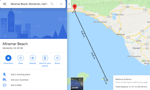
| − | It has been determined that the claimed viewing location is. Distance [https://www.google.com/maps/place/Miramar+Beach,+Montecito,+CA+93108/@34.1870437,-119.4175135,10.21z/data=!4m5!3m4!1s0x80e9123e9b130463:0xf3184df4380b341!8m2!3d34.4196048!4d-119.6297719 according to Google Maps]: | + | It has been determined that the claimed viewing location is correct. Distance [https://www.google.com/maps/place/Miramar+Beach,+Montecito,+CA+93108/@34.1870437,-119.4175135,10.21z/data=!4m5!3m4!1s0x80e9123e9b130463:0xf3184df4380b341!8m2!3d34.4196048!4d-119.6297719 according to Google Maps]: |
[[File:Anacapa Island Distance.png|600px]] | [[File:Anacapa Island Distance.png|600px]] | ||
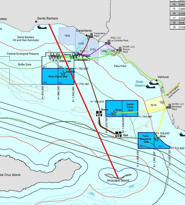
| − | The following map shows a red line from Miramar Beach to Anacapa Island, showing that the observer is looking between several oil platforms to the island: | + | The following map from forum member Stash shows a red line from Miramar Beach to Anacapa Island, showing that the observer is looking between several oil platforms to the island: |
[[File:Anacapa Island Platform Map.jpg|600px]] | [[File:Anacapa Island Platform Map.jpg|600px]] | ||
| Line 29: | Line 29: | ||
[[File:Anacapa Island Platform View.jpg|600px]] | [[File:Anacapa Island Platform View.jpg|600px]] | ||
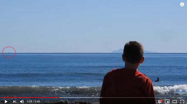
| − | Platform | + | Platform Grace is further away and appears when the observer begins to zoom at 2:08: |
[[File:Anacapa Island Platform Grace.jpg|600px]] | [[File:Anacapa Island Platform Grace.jpg|600px]] | ||
| + | |||
| + | [[Category:Form and Magnitude]] | ||
| + | [[Category:Ancient Greeks]] | ||
| + | [[Category:Optics]] | ||
| + | [[Category:Sinking Ship]] | ||
Latest revision as of 17:22, 15 October 2022
St. Helena
Zetetic Cosmogony (1899)
by Thomas Winship
Full Text Link
p.21
“ In September, 1898, I received a letter from Australia in which the writer says: "In the year 1872 I was on board the ship ‘Thomas Wood,’ Capt. Gibson from China to London. Owing to making a long passage, we ran short of provisions, and so short after rounding the Cape that the Captain spoke of putting into St. Helena for a supply. It was then my hobby to get the first glimpse of land, make a survey, just as the sun would be rising. The island was clearly in view, well on the starboard bow. I reported this to Capt. Gibson. He disbelieved me, saying it was impossible as we were 75 miles distant. He, however, offered me paper and pencil to sketch the land I saw. This I did. He then said, ‘you are right,’ and shaped his course accordingly. I had never seen the Island before and could not have described the shape of it had I not seen it." St. Helena is a high volcanic island, and if my informant had seen the top only, there would have to be an allowance made for the height of the land, but as he sketched the island he must have seen the whole of it, which should have been 3,650 feet below the line of sight, if the world be a globe. ”
Anacapa Islands
From Miramar Beach in California the Anacapa Islands have been seen from sea level:
Location Analysis
It has been determined that the claimed viewing location is correct. Distance according to Google Maps:
The following map from forum member Stash shows a red line from Miramar Beach to Anacapa Island, showing that the observer is looking between several oil platforms to the island:
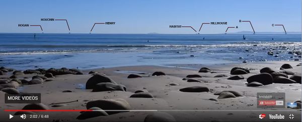
The unzoomed view shows the island between the platforms:
Platform Grace is further away and appears when the observer begins to zoom at 2:08:


