Bi-Polar Model
The Bi-Polar Model is a model of the earth which was first devised by Lady Blount's Universal Zetetic Society, the direct precursor of the Flat Earth Society, in the the early twentieth century after the discovery of the South Pole. This model features two poles and an Antarctic continent. An 'Ice Wall' still exists in this model, but it is not Antarctica. It is assumed that beyond the rays of the sun the waters will naturally freeze.
Explanatory Video
Flat Earth Crush has produced content on the Bi-Polar model which showcases some of the benefits of its sun model. It should be noted that the author has mentioned in other videos on the topic that he using the selected map as an example only for his purposes. Runtime: 15m
Related videos by Flat Earth Crush:
Maps
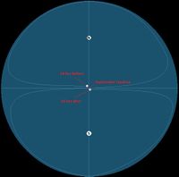
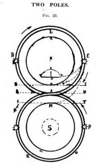
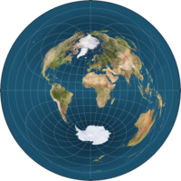
There are a wide variety of continental layout possibilities for Bi-Polar map. The continental layout is unknown and has yet to be fully researched due to ambiguities of jet streams, flight routing, and non-direct flights. The Bi-Polar model is sometimes illustrated with vertical circles, vertical ovals, or with a placeholder map.
- 1. From Bobby Shafto
- 2. Yearly sun path from p.30 of The Sea-Earth Globe and and its Monstrous Hypothetical Motions (1918) by Zetetes
- 3. Origin Unknown
Flat Earth proponent Sandokhan is credited with creating the most common Bi-Polar map layout.
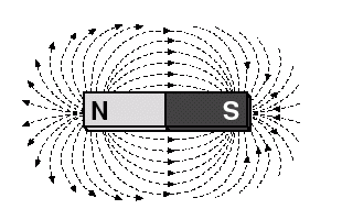
Circumnavigation involves traveling Eastwards or Westwards in relation to the magnetic field lines. On a Bi-Polar model the magnetic field lines would spread out from the North and South poles like the magnetic field lines on a bar magnet.
The needle of a compass would align with those magnetic field lines in the navigator's local area. Since East and West are at right angles to the field lines, moving East or West in relation to those field lines would take one in a circle around the North or South poles. This also implies that if one were to follow the magnetic field lines North or South that they would eventually get to the North South poles.
It should be noted that the magnetic field lines which are produced by a magnet always wrap around and connect to the opposite pole and that none travel forever into space.
Celestial Rotation
In the Bi-Polar model the stars above the earth are rotating in one direction in the Northern Hemiplane and in the opposite direction in the Southern Hemiplane, like a set of interlocked gears.
Eastward Sunrise
Q. How the sun can rise from near the east and set near the west under this configuration?
A. An answer to this query may be that it is similar to its operation in the standard Monopole model. When we observe the sun, we are observing its projection upon the atmolayer. The sun which is seen is local and individual to each observer. Accordingly, the easterly sunrise is a consequence of the following:
- The points along the edges of the sun's circular area of light are sunrise (or sunset).
- Our vision is very limited. One cannot see infinitely into the distance.
Sunrise will occur from an eastwardly direction as a natural consequence of the observer's limited range of vision. The sun's circular area of light generally intersects the observer's area of vision from an Eastwardly direction. During Equinox the sun's circular area of light is pivoting around itself. The points along the edge of the sun's area of light are close to traveling along your latitude line, and will intersect and appear from near the East, but not exactly.
If a cloud were traveling along the circle of your latitude line, and you only see it when it is close to you, would you see it appear from the east or near the east? The same explanation for this occurrence is given for the local sun and the manifestation of its initial Eastward bearing.
For additional details see: Equinox - A Flat Earth Equinox


