Difference between revisions of "Coriolis Effect (Weather)"
Tom Bishop (talk | contribs) |
Tom Bishop (talk | contribs) |
||
| (303 intermediate revisions by 3 users not shown) | |||
| Line 1: | Line 1: | ||
| − | ''' | + | According to proponents of the Coriolis Effect, in the ''Northern Hemisphere'' wind systems rotate ''counter-clockwise'', and in the ''Southern Hemisphere'' wind systems will rotate ''clockwise''. This is provided as evidence of the Coriolis Effect, and therefore, as evidence of the diurnal motion of the earth. We find, however, that the permanent wind and water systems of the earth rotate in a contradictory manner to what is alleged by the Coriolis Effect. It is mainly the tropical cyclones which originate from certain patterns of wind currents near the equator that rotate with the correct direction. |
| − | + | Dr. Anantha Aiyyer of NC State University explains that, due to the rotation of the earth, systems should rotate counter-clockwise in the Northern Hemisphere and clockwise in the Southern Hemisphere. | |
| − | + | https://www.newsobserver.com/news/technology/article103760221.html ([http://archive.fo/NV4h5 Archive]) | |
| − | |||
| − | https://www.newsobserver.com/news/technology/article103760221.html | ||
{{cite|'''Q:''' Why do hurricanes go counterclockwise in the northern hemisphere and clockwise in the southern hemisphere? | {{cite|'''Q:''' Why do hurricanes go counterclockwise in the northern hemisphere and clockwise in the southern hemisphere? | ||
| Line 13: | Line 11: | ||
We note that hurricanes spin in the same direction as the earth’s hemisphere (as viewed from the poles) they are located in. This is not a coincidence. The atmosphere is attached to the spinning earth and as a result every column of air is also spinning. When that inherent spin is concentrated (this happens when air convergences into an area) we get rotating storms like hurricanes. As the sense of rotation is opposite in the two hemispheres, this leads to oppositely spinning hurricanes.}} | We note that hurricanes spin in the same direction as the earth’s hemisphere (as viewed from the poles) they are located in. This is not a coincidence. The atmosphere is attached to the spinning earth and as a result every column of air is also spinning. When that inherent spin is concentrated (this happens when air convergences into an area) we get rotating storms like hurricanes. As the sense of rotation is opposite in the two hemispheres, this leads to oppositely spinning hurricanes.}} | ||
| − | =Prevailing | + | The National Geographic issues the same depiction: |
| + | |||
| + | https://www.nationalgeographic.org/encyclopedia/wind/ ([http://archive.fo/TSgEk Archive]) | ||
| + | |||
| + | {{cite|The Coriolis effect makes wind systems twist counter-clockwise in the Northern Hemisphere and clockwise in the Southern Hemisphere.}} | ||
| + | |||
| + | =Prevailing Wind and Ocean Systems= | ||
| − | "Prevailing Winds" and "Trade Winds" are the world's large permanent wind systems. When we look at the permanent wind | + | "Prevailing Winds" and "Trade Winds" are the world's large permanent wind systems which put the ocean systems into motion. When we look at the permanent wind and ocean systems of the world, we find the counter-clockwise rule of the Northern Hemisphere and the clockwise rule of the Southern Hemisphere to be untrue. Earth's large permanent wind and ocean systems are rotating in a manner ''contrary'' to the alleged Coriolis Effect. |
| − | + | [https://books.google.com/books?id=54d6I4947wIC&pg=PA28&hl=en&sa=X&ved=0ahUKEwiP3_S1_cvjAhXSTd8KHdEcDUo4ChDoAQhRMAc#v=onepage&q&f=false The Challence of Arctic Shipping: Science, Environmental Assessment, and Human Values] on p.28 pp.3 says: | |
| − | + | {{cite|Observations indicate that surface currents are chiefly wind-driven.}} | |
| − | = | + | [https://books.google.com/books?id=8kFPh_SvnAIC&lpg=PA516&pg=PA516#v=onepage&q&f=false Atmosphere-Ocean Dynamics, Volume 30] on p.516 pp.2 tells us: |
| − | Coriolis Effect proponents point to the rotation of hurricanes. In the Northern Hemisphere | + | {{cite|There is little doubt that the major surface currents are predominantly wind-driven}} |
| + | |||
| + | ==Prevailing Currents of the Pacific== | ||
| + | |||
| + | '''Prevailing Currents of the Pacific''' (Click for bigger) | ||
| + | |||
| + | [[File:Prevailing_Currents_Pacific.png|500px]] | ||
| + | |||
| + | See also: [https://wiki.tfes.org/images/e/ef/Ocean_currents_1943_%28borderless%29.png Prevailing Currents (World)] ([https://en.wikipedia.org/wiki/Ocean_current#/media/File:Ocean_currents_1943_(borderless)3.png Source]) | ||
| + | |||
| + | Map from Atlas of World Maps, United States Army Service Forces, Army Specialized Training Division. Army Service Forces Manual M-101 (1943). | ||
| + | |||
| + | ==Prevailing Winds (Generalized)== | ||
| + | |||
| + | Below we find a world map which shows a ''generalized'' pattern of the wind rotation. One should note that the rotations seen are ''clockwise'' in the Northern Hemisphere and ''counter-clockwise'' in the Southern Hemisphere, which is opposite from the "Coriolis Effect". | ||
| + | |||
| + | [[File:Prevailing Winds Generalized.jpg|500px]] | ||
| + | |||
| + | ==North Pole Gyre== | ||
| + | |||
| + | In fact, at the North Pole, where the Coriolis Effect is supposedly the greatest, we find a gyre that is traveling directly through the North Pole and rotating in a clockwise direction, opposite from the Coriolis Effect. | ||
| + | |||
| + | [[File:Coriolis North Pole.png|400px]] [[File:Beaufort gyre.jpg|375px]] | ||
| + | |||
| + | Source: | ||
| + | :—''[https://books.google.com/books?id=gNjYAgAAQBAJ&lpg=PP1&pg=PT6#v=onepage&q&f=false Moby-Duck: The True Story of 28,800 Bath Toys Lost at Sea]'' by Donovan Hohn | ||
| + | :—[https://nsidc.org/cryosphere/seaice/processes/circulation.html National Snow & Ice Data Center] ([https://web.archive.org/web/20190411215416/https://nsidc.org/cryosphere/seaice/processes/circulation.html Archive]) | ||
| + | |||
| + | ===Greatest at the Poles=== | ||
| + | |||
| + | A reference that that the Coriolis Effect is greatest at the poles can be seen on p.4 of ''[https://www.ametsoc.org/ams/index.cfm/education-careers/education-program/k-12-teachers/project-atmosphere/training-opportunities/project-atmosphere-peer-led-training/project-atmosphere-peer-training-resources/coriolis-effect-module/#:~:text=The%20effect%20of%20Earth's%20rotation,from%20above%20the%20North%20Pole. Coriolis Effect: Because the Earth Turns - Teacher's Guide]'' ([https://web.archive.org/web/20200823002001/https://www.ametsoc.org/ams/index.cfm/education-careers/education-program/k-12-teachers/project-atmosphere/training-opportunities/project-atmosphere-peer-led-training/project-atmosphere-peer-training-resources/coriolis-effect-module/#:~:text=The%2520effect%2520of%2520Earth's%2520rotation,from%2520above%2520the%2520North%2520Pole. Archive]) by the American Meteorological Society: | ||
| + | |||
| + | {{cite|The effect of Earth’s rotation on horizontally moving objects is greatest at the poles. The Coriolis deflection decreases as latitude decreases, until it is zero at the equator.}} | ||
| + | |||
| + | ==Erosion== | ||
| + | |||
| + | According to civil and geotechnical engineer [https://www.linkedin.com/in/gillian-jill-s-holmes-a64a9525 Gillian S. Holmes] in her [https://www.encyclopedia.com/earth-and-environment/atmosphere-and-weather/weather-and-climate-terms-and-concepts/coriolis-effect encyclopedia.com Coriolis Effect article] ([https://web.archive.org/web/20190418174258/https://www.encyclopedia.com/earth-and-environment/atmosphere-and-weather/weather-and-climate-terms-and-concepts/coriolis-effect Archive]) on the topic of erosion: | ||
| + | |||
| + | {{cite|For many years, geologists have used the Coriolis effect to suggest that right banks of rivers will tend to erode more rapidly than left banks in the Northern Hemisphere; this has been proven not to be true.}} | ||
| + | |||
| + | ==Tornadoes== | ||
| + | |||
| + | North Carolina's Climate Office [https://web.archive.org/web/20190620230404/https://climate.ncsu.edu/edu/Coriolis says]: | ||
| + | |||
| + | {{cite|Tornadoes are not impacted by the Coriolis Effect because they are so small in scale and short in duration.}} | ||
| + | |||
| + | American Scientist [https://web.archive.org/web/20190620230612/https://www.americanscientist.org/blog/science-culture/the-coriolis-and-the-commode says]: | ||
| + | |||
| + | {{cite|A tornado, however, has a high horizontal velocity (meaning it spins really fast) and a relatively small size. Its Rossby number is large. The Earth’s rotation should not affect the way tornadoes spin. And in fact you can see tornadoes rotating in counterclockwise and clockwise directions in either hemisphere.}} | ||
| + | |||
| + | =Hurricanes and Tropical Cyclones= | ||
| + | |||
| + | Coriolis Effect proponents mainly point to the rotation of hurricanes and other tropical cyclones. In the Northern Hemisphere tropical cyclones rotate counter-clockwise, and in the Southern Hemisphere tropical cyclones rotate clockwise, true to the Coriolis Effect. While researching this claim, we find that these rotational directions are generally true for the hurricanes and tropical cyclones. | ||
| + | |||
| + | Unlike the permanent wind and water systems of the earth, however, the hurricanes and tropical cyclones are special and temporary weather systems which have an average lifespan of about 9 days<sup>[https://wiki.tfes.org/Coriolis_Effect_(Weather)#Average_Life]</sup>. The directions of rotation of these temporary systems are entirely explainable with known and existing phenomena called Kelvin Waves which do not require the Coriolis Effect. Indeed, the National Oceanic and Atmospheric Administration (NOAA) has verified Kelvin Waves to occur during cyclone development, and now uses them in their early warning systems<sup>[https://wiki.tfes.org/Coriolis_Effect_(Weather)#Atmospheric_Kelvin_Waves_Confirmed_in_Development_of_Hurricanes]</sup>. | ||
==Counter-Rotating Vortexes== | ==Counter-Rotating Vortexes== | ||
| − | To explain why the hurricanes rotate oppositely from each other point to the fact that Hurricanes develop near the equator, and that at the equator there exists a strong wind current called the Equatorial Counter Current, which is a | + | To explain why the hurricanes rotate oppositely from each other we point to the fact that the Hurricanes and other tropical cyclones develop near the equator, and that at the equator there exists a strong wind current called the Equatorial Counter Current, which is a strong permanent easterly-flowing wind current. This Counter Current runs in an opposite direction to westerly-flowing currents that are immediately North and South of it. Since the atmosphere is generally characterized as a fluid, we can imagine this as a water current which moves against the flow of the waters around it. |
| + | |||
| + | We look to the following videos, where friction in water creates oppositely rotating vortexes: | ||
| + | |||
| + | ::*[https://www.youtube.com/watch?v=GujarnONUkQ '''Wooden Spoon Stroking Through Water Creates Counter-Rotating Vortexes'''] (1m29s)<br> | ||
| + | |||
| + | ::*[https://youtu.be/hUBocmQil00?t=135 '''Dinner Plate Creates Counter-Rotating Vortexes in a Swimming Pool'''] (2m20s) | ||
| + | |||
| + | The above videos show the creation of counter-rotating vortexes when the water is disturbed by plates or spoons. | ||
| + | |||
| + | [[File:Twin-Vortex-Spoon.gif]] | ||
| + | |||
| + | ===Kelvin Wave Pattern (Water)=== | ||
| + | |||
| + | The oppositely rotating vortexes in the videos above are caused by the Kelvin Wave Pattern. When an object disturbs water it will leave a wake in its path, which fans out and curves in opposite directions. | ||
| − | + | [[File:Boat wake.gif]] | |
| − | + | Along these oppositely curving patterns water rushes towards the body to fill in the gap left by the disturbance. The curves of this moving water system themselves also flow to follow the direction of the body. If the boat were traveling eastwards the flow of the water on the curved paths would be traveling counter-clockwise to the north of the boat and clockwise to the south of the boat, like the "Coriolis Effect". | |
| − | |||
| − | + | As demonstration of these curving patterns, we find a video of a [https://www.youtube.com/watch?v=PP35lbrx0JQ model toy boat making curved wakes behind it]. Note that the boat leaves behind curved paths, and that these paths follow the boat once it passes, indicating the direction of flow. | |
| − | + | The University of British Columbia [https://www.math.ubc.ca/~cass/courses/m309-01a/carmen/Mainpage.htm provides a technical assessment of the Kelvin Wave Pattern on water] ([http://archive.fo/D48QL Archive]) | |
| − | + | ===Kelvin-Rossby Wave Pattern (Atmospheric)=== | |
| − | - At the equator exists a strong and permanent | + | A 2000 study describes the creation of Kelvin wave patterns created by Rossby wind current collisions over equatorial "warm pools": |
| + | |||
| + | [https://pdfs.semanticscholar.org/2373/0a9f845e59bd7250c37c381a0d00a3b40321.pdf Convection over the Pacific Warm Pool in relation to the Atmospheric Kelvin – Rossby Wave] ([https://web.archive.org/web/20181108210640/https://pdfs.semanticscholar.org/2373/0a9f845e59bd7250c37c381a0d00a3b40321.pdf Archive]) | ||
| + | |||
| + | Abstract: {{cite|Deep convection over the western tropical Pacific warm pool is analyzed in terms of its relation to the atmospheric Kelvin–Rossby wave, which dominates the large-scale flow during the austral summer. The study uses Doppler radar data collected by aircraft and ship radars during different time periods in the Tropical Ocean Global Atmosphere Coupled Ocean–Atmosphere Response Experiment to characterize the mesoscale circulations of organized convective cloud systems occurring throughout the season.}} | ||
| + | |||
| + | [[File:Kelvin-Rossby Wave.png|800px]] | ||
| + | |||
| + | Diagram Caption: {{cite|FIG. 1. Zonally asymmetric circulation produced by a deep heating anomaly over the equator (stippled). (a) Plan view of surface motion. (b) Streamlines in a vertical cross section over the equator. (From Gill 1980 as shown by Salby 1996.)}} | ||
| + | |||
| + | According to the above, when wind currents collide over "warm pools" at the equator counter-rotating wind patterns are created. | ||
| + | |||
| + | We see that in the diagram the northern system is rotating counter-clockwise while the southern system rotates clockwise, just as was depicted in the premise. | ||
| + | |||
| + | The system in the diagram above is described as having a strong westerly core: {{cite|The deep convection was concentrated both in the strong westerly core of the system and in the gyres.}} | ||
| + | |||
| + | Further, we see in the illustration that these gyres are rotating around centers of low pressure, just as the hurricanes and tropical cyclones do. The [https://www.nationalgeographic.com/environment/natural-disasters/hurricanes/ National Geographic says] ([http://archive.fo/OsIgt Archive]): {{cite|Hurricanes spin around a low-pressure center known as the “eye.” Sinking air makes this 20- to 30-mile-wide (32- to 48-kilometer-wide) area notoriously calm. But the eye is surrounded by a circular “eye wall” that hosts the storm’s strongest winds and rain.}} | ||
| + | |||
| + | ===Counter Current Activity Correlation=== | ||
| + | |||
| + | The following is a study which associates curious activity in eastwardly flowing Equatorial Counter Current, also known as the North Equatorial Counter Current, with the development of hurricanes. | ||
| + | |||
| + | [https://www.ocean-sci.net/14/633/2018/os-14-633-2018.pdf On the role of the North Equatorial Counter Current during a strong El Niño] ([https://web.archive.org/web/20181108210707/https://www.ocean-sci.net/14/633/2018/os-14-633-2018.pdf Archive]) | ||
| + | |||
| + | Abstract: {{cite|An analysis of archived data from the NEMO 1/12th degree global ocean model shows the importance of the North Equatorial Counter Current (NECC) in the development of the strong 1982–1983 and 1997–1998 El Niños.}} | ||
| + | |||
| + | Text: {{cite|The forcing fields show that '''periods with strong westerly winds occurred at the Equator during the development of both the two strong El Niños studied and the warm pool event'''}} | ||
| + | |||
| + | Hence, we find that strong westerly winds at the equator, in conjunction with the warm pool event, was associated with the development of the El Niño hurricanes. | ||
| + | |||
| + | ===Atmospheric Kelvin Waves Confirmed in Development of Hurricanes=== | ||
| + | |||
| + | In 2015 meteorologists confirmed the influence of atmospheric Kelvin Waves in the development of tropical cyclones. | ||
| + | |||
| + | [https://ncics.org/cics-news/kelvin-waves-and-tropical-cyclogenesis-a-global-survey/ Kelvin Waves and Tropical Cyclogenesis: A Global Survey] ([https://web.archive.org/web/20181110004145/https://ncics.org/cics-news/kelvin-waves-and-tropical-cyclogenesis-a-global-survey/ Archive] | [https://web.archive.org/web/20170510070502/http://journals.ametsoc.org/doi/pdf/10.1175/MWR-D-15-0111.1 Study]) | ||
| + | |||
| + | {{cite|'''A new study by Carl Schreck III of the North Carolina Institute for Climate Studies and North Carolina State University provides important insights into the way long-lived tropical weather patterns known as Kelvin waves influence the development of tropical cyclones. The findings are already being used by NOAA’s Climate Prediction Center and National Hurricane Center in forecasting tropical storm development.''' | ||
| + | |||
| + | Atmospheric Kelvin waves are tropical rainfall systems accompanied by distinctive westerly and easterly wind patterns. These waves move eastward around the Earth and can circumnavigate the tropics over the course of a month.}} | ||
| + | |||
| + | ===Twin Cyclones=== | ||
| + | |||
| + | '''Q.''' If the tropical cyclones are created by Kelvin Waves, then why don't we ever see twin cyclones? | ||
| + | |||
| + | '''A.''' According to the University Corporation for Atmospheric Research they do come in pairs. The [http://kejian1.cmatc.cn/vod/comet/tropical/MJO_EqWaves/navmenu.php_tab_1_page_5.0.0_type_text.htm following case study] ([https://web.archive.org/web/20191221022112/http://kejian1.cmatc.cn/vod/comet/tropical/MJO_EqWaves/navmenu.php_tab_1_page_5.0.0_type_text.htm Archive]) has images of twin cyclones in development via Kelvin Waves. From the Summary section of the document we see infrared weather imagery from "satellite" data:<br><br> | ||
| + | |||
| + | {{cite|On 4 May 2002, a linear formation of convection became a Kelvin wave straddling the equator and propagating eastward.}} | ||
| + | |||
| + | [[File:Twin Cyclones 1.jpg]] | ||
| + | |||
| + | {{cite|Consequently, the convection from the active Kelvin wave generated twin vortices on 6 to 7 May 2002. These represented a pair of westward-moving equatorial Rossby waves.}} | ||
| + | |||
| + | [[File:Twin Cyclones 2.jpg]] | ||
| + | |||
| + | {{cite|These equatorial Rossby waves provided the circulations from which two additional tropical cyclones developed: TC2B and Tropical Cyclone Errol. These are shown as they were on 10 May 2002 at 18 UTC, below.}} | ||
| + | |||
| + | [[File:Twin Cyclones 3.jpg]] | ||
| + | |||
| + | ==Crossing the Equator== | ||
| + | |||
| + | Coriolis Effect proponents further assert that after they form the cyclones do not cross over the equator into the opposing hemisphere. While this is true, this argument implicitly assumes that the hurricanes are wandering around randomly and can travel into the opposite hemisphere. | ||
| + | |||
| + | It is seen that hurricanes do not move around randomly, but are [https://books.google.com/books?id=uTfM9Gtei_4C&lpg=PA77&ots=fuZn1ivbQV&dq=Hurricanes%20are%20%22steered%22%20by%20the%20prevailing%20wind%20currents%20that%20surround%20the%20storm%20from%20the%20surface%20to%2050%2C000%20feet&pg=PA77#v=onepage&q&f=false steered by high altitude wind currents]: | ||
| + | |||
| + | {{cite|Hurricanes are "steered" by the prevailing wind currents that surround the storm from the surface to 50,000 feet or more. The storms move in the direction of these currents and with their average speed. }} | ||
| + | |||
| + | In addition: | ||
| + | |||
| + | - At the equator exists a strong and permanent easterly-flowing current called the Equatorial Counter Current, which is bordered on the North and South by permanent westerly-flowing currents called the Northern and Southern Equatorial currents.<sup>[https://wiki.tfes.org/Coriolis_Effect_(Weather)#Currents_at_the_Equator]</sup> Such a hurricane would need to defeat these currents in order to make it across. | ||
- Hurricanes are created by these topical wind currents, and are sent spiraling Northward or Southward away from the tropical regions of the equator to cause havoc towards temperate regions of the North or South. | - Hurricanes are created by these topical wind currents, and are sent spiraling Northward or Southward away from the tropical regions of the equator to cause havoc towards temperate regions of the North or South. | ||
| − | - Hurricanes have relatively short lives | + | - Hurricanes have relatively short lives with an average of about 9 days<sup>[https://wiki.tfes.org/Coriolis_Effect_(Weather)#Average_Life]</sup>. |
| − | The above points make it unreasonable for a hurricane to return to | + | The above points may make it unreasonable for a hurricane to return to the equator and cross to the other side. |
==Origin of Hurricanes== | ==Origin of Hurricanes== | ||
| − | + | ===Where Are Hurricanes Formed?=== | |
| − | https://scijinks.gov/hurricane/ | + | https://scijinks.gov/hurricane/ ([http://archive.fo/2Q9Dm Archive]) |
| − | {{cite|Hurricanes are the most violent storms on Earth. They ''form near the equator | + | {{cite|Hurricanes are the most violent storms on Earth. They ''form near the equator over warm ocean waters''.}} |
| − | From https://weloveweather.tv/hurricanes-equator/ we see the following graphic, showing hurricanes originating in the tropical regions of near the equator: | + | ===Hurricane Path Map=== |
| + | |||
| + | From https://weloveweather.tv/hurricanes-equator/ ([https://web.archive.org/web/20181106153343/https://weloveweather.tv/hurricanes-equator/ Archive]) we see the following graphic, showing hurricanes originating in the tropical regions of near the equator: | ||
'''150 years of tropical cyclone tracks through 2006''' | '''150 years of tropical cyclone tracks through 2006''' | ||
| Line 63: | Line 204: | ||
{{cite|The graphic above clearly reveals that hurricanes (Atlantic basin, E. Pacific), typhoons (W. Pacific), and cyclones (Indian Ocean, Australia) rarely if ever form between 5 deg North and 5 deg South latitudes, respectively.}} | {{cite|The graphic above clearly reveals that hurricanes (Atlantic basin, E. Pacific), typhoons (W. Pacific), and cyclones (Indian Ocean, Australia) rarely if ever form between 5 deg North and 5 deg South latitudes, respectively.}} | ||
| + | |||
| + | ===Hurricane Classification=== | ||
| + | |||
| + | Per the gap at the equator, wind systems do not necessarily reach the classification of storms or hurricanes the moment they form. | ||
| + | |||
| + | https://social.selective.com/articles/how-do-hurricanes-develop ([https://web.archive.org/web/20201207235753/https://social.selective.com/articles/how-do-hurricanes-develop Archive]) | ||
| + | |||
| + | {{cite|Also known as cyclones, hurricanes don't become hurricanes until they've reached a certain wind speed. Generally speaking when there are sustained wind gusts traveling at 74 miles per hour, this is the textbook definition of a hurricane, or what forecasters call a Category 1. }} | ||
==Hurricane Life Cycle== | ==Hurricane Life Cycle== | ||
| − | http://hurricanescience.org/science/science/hurricanelifecycle/ | + | http://hurricanescience.org/science/science/hurricanelifecycle/ ([http://archive.fo/sbKYm Archive]) |
{{cite|Most hurricanes follow a similar cycle of development, called a hurricane life cycle. These life cycles may run their course in as little as a day or last as long as a month. The longest-lasting tropical cyclone ever observed was Hurricane/Typhoon John, which existed for 31 days as it traveled a 13,000 km (8,100 mi) path from the eastern Pacific to the western Pacific and back to the central Pacific. There have also been many tropical cyclones that remained at hurricane intensity for 12 hours or less, including the Atlantic hurricane, Ernesto, in 2006.}} | {{cite|Most hurricanes follow a similar cycle of development, called a hurricane life cycle. These life cycles may run their course in as little as a day or last as long as a month. The longest-lasting tropical cyclone ever observed was Hurricane/Typhoon John, which existed for 31 days as it traveled a 13,000 km (8,100 mi) path from the eastern Pacific to the western Pacific and back to the central Pacific. There have also been many tropical cyclones that remained at hurricane intensity for 12 hours or less, including the Atlantic hurricane, Ernesto, in 2006.}} | ||
| Line 72: | Line 221: | ||
===Average Life=== | ===Average Life=== | ||
| − | http://www.wxresearch.org/family/pg4.html | + | http://www.wxresearch.org/family/pg4.html ([http://archive.fo/lC3PQ Archive]) |
{{cite|"Average life of a hurricane, determined by time and place of origin and rate of forward movement, is nine days." (TCMC, 1976).}} | {{cite|"Average life of a hurricane, determined by time and place of origin and rate of forward movement, is nine days." (TCMC, 1976).}} | ||
| − | http://shopkins.uga.edu/dir/ | + | http://shopkins.uga.edu/dir/GEOG1111/Lectures1111/LECT15Hurricanes-eLC.html ([https://web.archive.org/web/20210204013242/http://shopkins.uga.edu/dir/GEOG1111/Lectures1111/LECT15Hurricanes-eLC.html Archive]) |
{{cite|Tropical systems have an average life span of from 7-10 days, but may last over 2 weeks. This covers from the first development of a Tropical Disturbance through to when a Hurricane finally dissipates.}} | {{cite|Tropical systems have an average life span of from 7-10 days, but may last over 2 weeks. This covers from the first development of a Tropical Disturbance through to when a Hurricane finally dissipates.}} | ||
| − | == | + | ==Currents at the Equator== |
| − | ===North Equatorial Current=== | + | ===North Equatorial Current (Westerly)=== |
| − | https://en.wikipedia.org/wiki/North_Equatorial_Current | + | https://en.wikipedia.org/wiki/North_Equatorial_Current ([http://archive.fo/ZREoU Archive]) |
{{cite|The North Equatorial Current is a significant Pacific and Atlantic Ocean current that flows east-to-west between about 10° north and 20° north. It is the southern side of a clockwise subtropical gyre. Despite its name, the North Equatorial Current is not connected to the equator. In both oceans, it is separated from the equatorial circulation by the Equatorial Countercurrent (also known as the North Equatorial Countercurrent), which flows eastward. The westward surface flow at the equator in both oceans is part of the South Equatorial Current.}} | {{cite|The North Equatorial Current is a significant Pacific and Atlantic Ocean current that flows east-to-west between about 10° north and 20° north. It is the southern side of a clockwise subtropical gyre. Despite its name, the North Equatorial Current is not connected to the equator. In both oceans, it is separated from the equatorial circulation by the Equatorial Countercurrent (also known as the North Equatorial Countercurrent), which flows eastward. The westward surface flow at the equator in both oceans is part of the South Equatorial Current.}} | ||
| − | ===Equatorial Counter Current=== | + | ===Equatorial Counter Current (Easterly)=== |
| − | https://en.wikipedia.org/wiki/Equatorial_Counter_Current | + | https://en.wikipedia.org/wiki/Equatorial_Counter_Current ([http://archive.fo/N5EcV Archive]) |
{{cite|The Equatorial Counter Current is an eastward flowing, wind-driven current which extends to depths of 100-150m in the Atlantic, Indian, and Pacific Oceans. More often called the North Equatorial Countercurrent (NECC), this current flows west-to-east at about 3-10° North}} | {{cite|The Equatorial Counter Current is an eastward flowing, wind-driven current which extends to depths of 100-150m in the Atlantic, Indian, and Pacific Oceans. More often called the North Equatorial Countercurrent (NECC), this current flows west-to-east at about 3-10° North}} | ||
| − | ===South Equatorial Current=== | + | ===South Equatorial Current (Westerly)=== |
| − | https://en.wikipedia.org/wiki/South_Equatorial_Current | + | https://en.wikipedia.org/wiki/South_Equatorial_Current ([http://archive.fo/dIYCh Archive]) |
{{cite|Ocean current in the Pacific, Atlantic, and Indian Ocean that flows east-to-west between the equator and about 20 degrees south. In the Pacific and Atlantic Oceans, it extends across the equator to about 5 degrees north.}} | {{cite|Ocean current in the Pacific, Atlantic, and Indian Ocean that flows east-to-west between the equator and about 20 degrees south. In the Pacific and Atlantic Oceans, it extends across the equator to about 5 degrees north.}} | ||
| − | = | + | =Addendum= |
| − | + | We suspect that if all of the ocean and wind patterns, systems, storms, and currents of the world were traveling in a reverse manner to which they travel, that the Coriolis Effect proponents would instead be championing the Prevailing Winds and Ocean Currents as a proof of the Coriolis Effect and the rotation of the earth, while blissfully ignoring the hurricanes. | |
| − | + | ==See Also== | |
| − | + | ''Flat Earth Topics on Rotation and Revolution'' | |
| + | |||
| + | :*'''[[Michelson-Morley Experiment]]''' - Light velocity experiment which suggests a lack of Earth's motion around the Sun | ||
| + | :*'''[[Sagnac Experiment]]''' - Experiments which show that light's velocity is indeed affected by detector motion | ||
| + | :*'''[[Airy's Failure]]''' - An experiment which suggests that the stars are in motion, rather than the Earth | ||
| + | :*'''[[Time Dilation by Latitude]]''' - The predicted time dilation caused by Earth's rotation does not occur | ||
| + | :*'''[[Aviation]]''' - Mechanical air flight assumes a flat, non-rotating Earth | ||
| − | + | ''Round Earth Topics on Rotation'' | |
| − | + | :*'''[[Foucault Pendulum]]''' - Pendulum device which is alleged to detect the rotation of Earth | |
| + | :*'''[[Coriolis Effect]]''' - Eastwards deflection of bodies caused by Earth's rotation | ||
| + | :*'''[[Coriolis Effect (Weather)]]''' - Hurricanes and other effects due to Earth's rotation | ||
| + | :*'''[[Ring Laser Gyroscope]]''' - Ring laser experiment alleged to observe the rotation of Earth | ||
| − | + | [[Category:General Physics]] | |
| + | [[Category:Rotation and Revolution]] | ||
Latest revision as of 23:04, 29 October 2023
According to proponents of the Coriolis Effect, in the Northern Hemisphere wind systems rotate counter-clockwise, and in the Southern Hemisphere wind systems will rotate clockwise. This is provided as evidence of the Coriolis Effect, and therefore, as evidence of the diurnal motion of the earth. We find, however, that the permanent wind and water systems of the earth rotate in a contradictory manner to what is alleged by the Coriolis Effect. It is mainly the tropical cyclones which originate from certain patterns of wind currents near the equator that rotate with the correct direction.
Dr. Anantha Aiyyer of NC State University explains that, due to the rotation of the earth, systems should rotate counter-clockwise in the Northern Hemisphere and clockwise in the Southern Hemisphere.
https://www.newsobserver.com/news/technology/article103760221.html (Archive)
“ Q: Why do hurricanes go counterclockwise in the northern hemisphere and clockwise in the southern hemisphere?
A: You can think of a hurricane as a spinning column of air that stretches from sea-level up to about 45,000 feet. Over much of this depth, air flows counter-clockwise in the northern hemisphere and clockwise in the southern hemisphere. To understand why, let’s consider the rotation of the earth. We know that the earth spins along an invisible axis from west to east. But if we look at it differently, something interesting jumps out. Imagine you are hovering above one of the poles and are looking down at the earth. Pick the North Pole and do this thought experiment. In what sense is the earth rotating? Counterclockwise. Now fly to the South Pole and look at the earth and notice its rotation. It will help to use a spinning tennis or basketball to visualize this. It now appears to spin clockwise.
We note that hurricanes spin in the same direction as the earth’s hemisphere (as viewed from the poles) they are located in. This is not a coincidence. The atmosphere is attached to the spinning earth and as a result every column of air is also spinning. When that inherent spin is concentrated (this happens when air convergences into an area) we get rotating storms like hurricanes. As the sense of rotation is opposite in the two hemispheres, this leads to oppositely spinning hurricanes. ”
The National Geographic issues the same depiction:
https://www.nationalgeographic.org/encyclopedia/wind/ (Archive)
“ The Coriolis effect makes wind systems twist counter-clockwise in the Northern Hemisphere and clockwise in the Southern Hemisphere. ”
Prevailing Wind and Ocean Systems
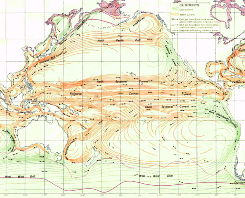
"Prevailing Winds" and "Trade Winds" are the world's large permanent wind systems which put the ocean systems into motion. When we look at the permanent wind and ocean systems of the world, we find the counter-clockwise rule of the Northern Hemisphere and the clockwise rule of the Southern Hemisphere to be untrue. Earth's large permanent wind and ocean systems are rotating in a manner contrary to the alleged Coriolis Effect.
The Challence of Arctic Shipping: Science, Environmental Assessment, and Human Values on p.28 pp.3 says:
“ Observations indicate that surface currents are chiefly wind-driven. ”
Atmosphere-Ocean Dynamics, Volume 30 on p.516 pp.2 tells us:
“ There is little doubt that the major surface currents are predominantly wind-driven ”
Prevailing Currents of the Pacific
Prevailing Currents of the Pacific (Click for bigger)
See also: Prevailing Currents (World) (Source)
Map from Atlas of World Maps, United States Army Service Forces, Army Specialized Training Division. Army Service Forces Manual M-101 (1943).
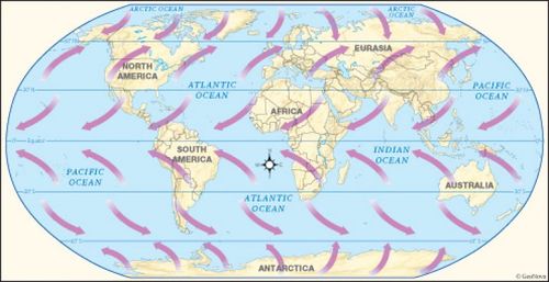
Prevailing Winds (Generalized)
Below we find a world map which shows a generalized pattern of the wind rotation. One should note that the rotations seen are clockwise in the Northern Hemisphere and counter-clockwise in the Southern Hemisphere, which is opposite from the "Coriolis Effect".
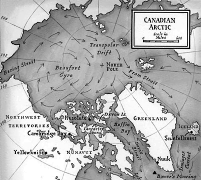
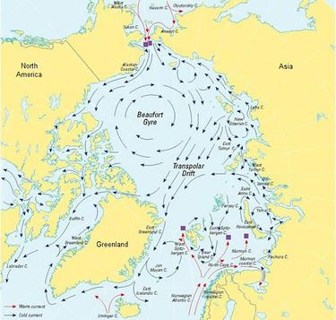
North Pole Gyre
In fact, at the North Pole, where the Coriolis Effect is supposedly the greatest, we find a gyre that is traveling directly through the North Pole and rotating in a clockwise direction, opposite from the Coriolis Effect.
Source:
- —Moby-Duck: The True Story of 28,800 Bath Toys Lost at Sea by Donovan Hohn
- —National Snow & Ice Data Center (Archive)
Greatest at the Poles
A reference that that the Coriolis Effect is greatest at the poles can be seen on p.4 of Coriolis Effect: Because the Earth Turns - Teacher's Guide (Archive) by the American Meteorological Society:
“ The effect of Earth’s rotation on horizontally moving objects is greatest at the poles. The Coriolis deflection decreases as latitude decreases, until it is zero at the equator. ”
Erosion
According to civil and geotechnical engineer Gillian S. Holmes in her encyclopedia.com Coriolis Effect article (Archive) on the topic of erosion:
“ For many years, geologists have used the Coriolis effect to suggest that right banks of rivers will tend to erode more rapidly than left banks in the Northern Hemisphere; this has been proven not to be true. ”
Tornadoes
North Carolina's Climate Office says:
“ Tornadoes are not impacted by the Coriolis Effect because they are so small in scale and short in duration. ”
American Scientist says:
“ A tornado, however, has a high horizontal velocity (meaning it spins really fast) and a relatively small size. Its Rossby number is large. The Earth’s rotation should not affect the way tornadoes spin. And in fact you can see tornadoes rotating in counterclockwise and clockwise directions in either hemisphere. ”
Hurricanes and Tropical Cyclones
Coriolis Effect proponents mainly point to the rotation of hurricanes and other tropical cyclones. In the Northern Hemisphere tropical cyclones rotate counter-clockwise, and in the Southern Hemisphere tropical cyclones rotate clockwise, true to the Coriolis Effect. While researching this claim, we find that these rotational directions are generally true for the hurricanes and tropical cyclones.
Unlike the permanent wind and water systems of the earth, however, the hurricanes and tropical cyclones are special and temporary weather systems which have an average lifespan of about 9 days[1]. The directions of rotation of these temporary systems are entirely explainable with known and existing phenomena called Kelvin Waves which do not require the Coriolis Effect. Indeed, the National Oceanic and Atmospheric Administration (NOAA) has verified Kelvin Waves to occur during cyclone development, and now uses them in their early warning systems[2].
Counter-Rotating Vortexes
To explain why the hurricanes rotate oppositely from each other we point to the fact that the Hurricanes and other tropical cyclones develop near the equator, and that at the equator there exists a strong wind current called the Equatorial Counter Current, which is a strong permanent easterly-flowing wind current. This Counter Current runs in an opposite direction to westerly-flowing currents that are immediately North and South of it. Since the atmosphere is generally characterized as a fluid, we can imagine this as a water current which moves against the flow of the waters around it.
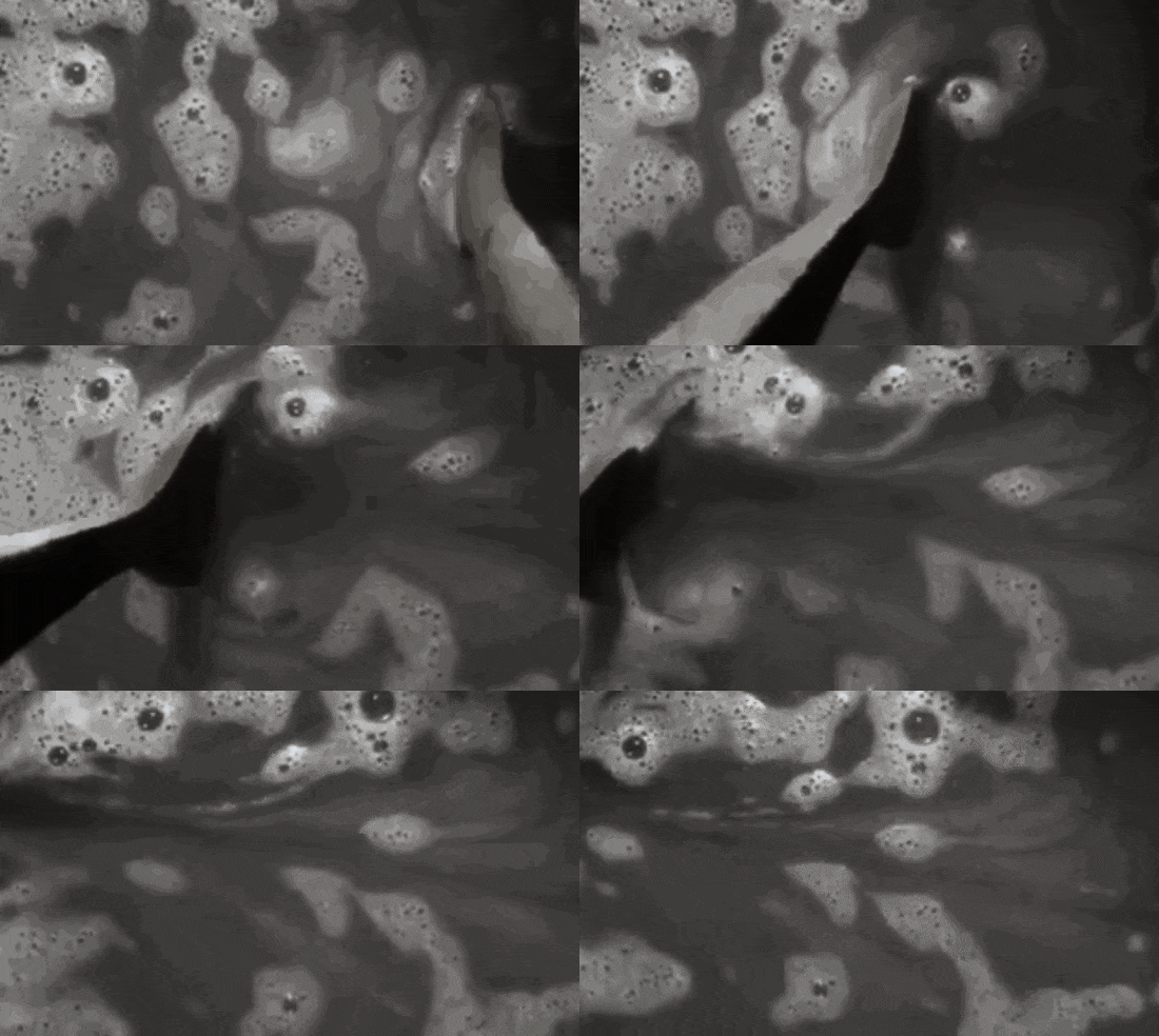
We look to the following videos, where friction in water creates oppositely rotating vortexes:
The above videos show the creation of counter-rotating vortexes when the water is disturbed by plates or spoons.
Kelvin Wave Pattern (Water)
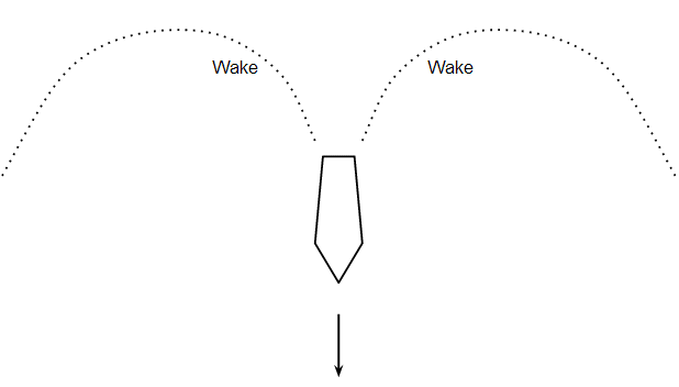
The oppositely rotating vortexes in the videos above are caused by the Kelvin Wave Pattern. When an object disturbs water it will leave a wake in its path, which fans out and curves in opposite directions.
Along these oppositely curving patterns water rushes towards the body to fill in the gap left by the disturbance. The curves of this moving water system themselves also flow to follow the direction of the body. If the boat were traveling eastwards the flow of the water on the curved paths would be traveling counter-clockwise to the north of the boat and clockwise to the south of the boat, like the "Coriolis Effect".
As demonstration of these curving patterns, we find a video of a model toy boat making curved wakes behind it. Note that the boat leaves behind curved paths, and that these paths follow the boat once it passes, indicating the direction of flow.
The University of British Columbia provides a technical assessment of the Kelvin Wave Pattern on water (Archive)
Kelvin-Rossby Wave Pattern (Atmospheric)
A 2000 study describes the creation of Kelvin wave patterns created by Rossby wind current collisions over equatorial "warm pools":
Convection over the Pacific Warm Pool in relation to the Atmospheric Kelvin – Rossby Wave (Archive)
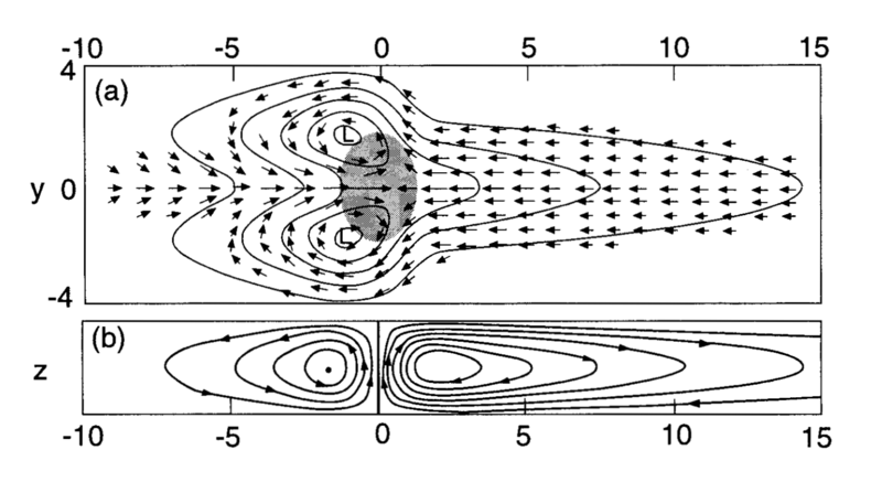
Abstract: “ Deep convection over the western tropical Pacific warm pool is analyzed in terms of its relation to the atmospheric Kelvin–Rossby wave, which dominates the large-scale flow during the austral summer. The study uses Doppler radar data collected by aircraft and ship radars during different time periods in the Tropical Ocean Global Atmosphere Coupled Ocean–Atmosphere Response Experiment to characterize the mesoscale circulations of organized convective cloud systems occurring throughout the season. ”
Diagram Caption: “ FIG. 1. Zonally asymmetric circulation produced by a deep heating anomaly over the equator (stippled). (a) Plan view of surface motion. (b) Streamlines in a vertical cross section over the equator. (From Gill 1980 as shown by Salby 1996.) ”
According to the above, when wind currents collide over "warm pools" at the equator counter-rotating wind patterns are created.
We see that in the diagram the northern system is rotating counter-clockwise while the southern system rotates clockwise, just as was depicted in the premise.
The system in the diagram above is described as having a strong westerly core: “ The deep convection was concentrated both in the strong westerly core of the system and in the gyres. ”
Further, we see in the illustration that these gyres are rotating around centers of low pressure, just as the hurricanes and tropical cyclones do. The National Geographic says (Archive): “ Hurricanes spin around a low-pressure center known as the “eye.” Sinking air makes this 20- to 30-mile-wide (32- to 48-kilometer-wide) area notoriously calm. But the eye is surrounded by a circular “eye wall” that hosts the storm’s strongest winds and rain. ”
Counter Current Activity Correlation
The following is a study which associates curious activity in eastwardly flowing Equatorial Counter Current, also known as the North Equatorial Counter Current, with the development of hurricanes.
On the role of the North Equatorial Counter Current during a strong El Niño (Archive)
Abstract: “ An analysis of archived data from the NEMO 1/12th degree global ocean model shows the importance of the North Equatorial Counter Current (NECC) in the development of the strong 1982–1983 and 1997–1998 El Niños. ”
Text: “ The forcing fields show that periods with strong westerly winds occurred at the Equator during the development of both the two strong El Niños studied and the warm pool event ”
Hence, we find that strong westerly winds at the equator, in conjunction with the warm pool event, was associated with the development of the El Niño hurricanes.
Atmospheric Kelvin Waves Confirmed in Development of Hurricanes
In 2015 meteorologists confirmed the influence of atmospheric Kelvin Waves in the development of tropical cyclones.
Kelvin Waves and Tropical Cyclogenesis: A Global Survey (Archive | Study)
“ A new study by Carl Schreck III of the North Carolina Institute for Climate Studies and North Carolina State University provides important insights into the way long-lived tropical weather patterns known as Kelvin waves influence the development of tropical cyclones. The findings are already being used by NOAA’s Climate Prediction Center and National Hurricane Center in forecasting tropical storm development.
Atmospheric Kelvin waves are tropical rainfall systems accompanied by distinctive westerly and easterly wind patterns. These waves move eastward around the Earth and can circumnavigate the tropics over the course of a month. ”
Twin Cyclones
Q. If the tropical cyclones are created by Kelvin Waves, then why don't we ever see twin cyclones?
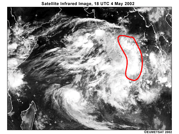
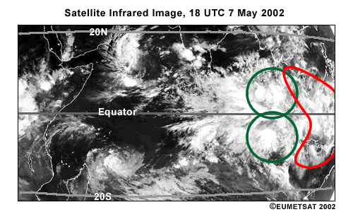
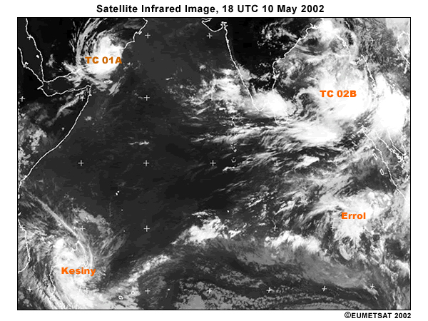
A. According to the University Corporation for Atmospheric Research they do come in pairs. The following case study (Archive) has images of twin cyclones in development via Kelvin Waves. From the Summary section of the document we see infrared weather imagery from "satellite" data:
“ On 4 May 2002, a linear formation of convection became a Kelvin wave straddling the equator and propagating eastward. ”
“ Consequently, the convection from the active Kelvin wave generated twin vortices on 6 to 7 May 2002. These represented a pair of westward-moving equatorial Rossby waves. ”
“ These equatorial Rossby waves provided the circulations from which two additional tropical cyclones developed: TC2B and Tropical Cyclone Errol. These are shown as they were on 10 May 2002 at 18 UTC, below. ”
Crossing the Equator
Coriolis Effect proponents further assert that after they form the cyclones do not cross over the equator into the opposing hemisphere. While this is true, this argument implicitly assumes that the hurricanes are wandering around randomly and can travel into the opposite hemisphere.
It is seen that hurricanes do not move around randomly, but are steered by high altitude wind currents:
“ Hurricanes are "steered" by the prevailing wind currents that surround the storm from the surface to 50,000 feet or more. The storms move in the direction of these currents and with their average speed. ”
In addition:
- At the equator exists a strong and permanent easterly-flowing current called the Equatorial Counter Current, which is bordered on the North and South by permanent westerly-flowing currents called the Northern and Southern Equatorial currents.[3] Such a hurricane would need to defeat these currents in order to make it across.
- Hurricanes are created by these topical wind currents, and are sent spiraling Northward or Southward away from the tropical regions of the equator to cause havoc towards temperate regions of the North or South.
- Hurricanes have relatively short lives with an average of about 9 days[4].
The above points may make it unreasonable for a hurricane to return to the equator and cross to the other side.
Origin of Hurricanes
Where Are Hurricanes Formed?
https://scijinks.gov/hurricane/ (Archive)
“ Hurricanes are the most violent storms on Earth. They form near the equator over warm ocean waters. ”
Hurricane Path Map
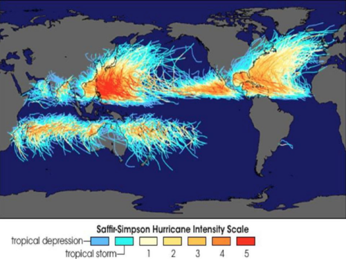
From https://weloveweather.tv/hurricanes-equator/ (Archive) we see the following graphic, showing hurricanes originating in the tropical regions of near the equator:
150 years of tropical cyclone tracks through 2006
“ The graphic above clearly reveals that hurricanes (Atlantic basin, E. Pacific), typhoons (W. Pacific), and cyclones (Indian Ocean, Australia) rarely if ever form between 5 deg North and 5 deg South latitudes, respectively. ”
Hurricane Classification
Per the gap at the equator, wind systems do not necessarily reach the classification of storms or hurricanes the moment they form.
https://social.selective.com/articles/how-do-hurricanes-develop (Archive)
“ Also known as cyclones, hurricanes don't become hurricanes until they've reached a certain wind speed. Generally speaking when there are sustained wind gusts traveling at 74 miles per hour, this is the textbook definition of a hurricane, or what forecasters call a Category 1. ”
Hurricane Life Cycle
http://hurricanescience.org/science/science/hurricanelifecycle/ (Archive)
“ Most hurricanes follow a similar cycle of development, called a hurricane life cycle. These life cycles may run their course in as little as a day or last as long as a month. The longest-lasting tropical cyclone ever observed was Hurricane/Typhoon John, which existed for 31 days as it traveled a 13,000 km (8,100 mi) path from the eastern Pacific to the western Pacific and back to the central Pacific. There have also been many tropical cyclones that remained at hurricane intensity for 12 hours or less, including the Atlantic hurricane, Ernesto, in 2006. ”
Average Life
http://www.wxresearch.org/family/pg4.html (Archive)
“ "Average life of a hurricane, determined by time and place of origin and rate of forward movement, is nine days." (TCMC, 1976). ”
http://shopkins.uga.edu/dir/GEOG1111/Lectures1111/LECT15Hurricanes-eLC.html (Archive)
“ Tropical systems have an average life span of from 7-10 days, but may last over 2 weeks. This covers from the first development of a Tropical Disturbance through to when a Hurricane finally dissipates. ”
Currents at the Equator
North Equatorial Current (Westerly)
https://en.wikipedia.org/wiki/North_Equatorial_Current (Archive)
“ The North Equatorial Current is a significant Pacific and Atlantic Ocean current that flows east-to-west between about 10° north and 20° north. It is the southern side of a clockwise subtropical gyre. Despite its name, the North Equatorial Current is not connected to the equator. In both oceans, it is separated from the equatorial circulation by the Equatorial Countercurrent (also known as the North Equatorial Countercurrent), which flows eastward. The westward surface flow at the equator in both oceans is part of the South Equatorial Current. ”
Equatorial Counter Current (Easterly)
https://en.wikipedia.org/wiki/Equatorial_Counter_Current (Archive)
“ The Equatorial Counter Current is an eastward flowing, wind-driven current which extends to depths of 100-150m in the Atlantic, Indian, and Pacific Oceans. More often called the North Equatorial Countercurrent (NECC), this current flows west-to-east at about 3-10° North ”
South Equatorial Current (Westerly)
https://en.wikipedia.org/wiki/South_Equatorial_Current (Archive)
“ Ocean current in the Pacific, Atlantic, and Indian Ocean that flows east-to-west between the equator and about 20 degrees south. In the Pacific and Atlantic Oceans, it extends across the equator to about 5 degrees north. ”
Addendum
We suspect that if all of the ocean and wind patterns, systems, storms, and currents of the world were traveling in a reverse manner to which they travel, that the Coriolis Effect proponents would instead be championing the Prevailing Winds and Ocean Currents as a proof of the Coriolis Effect and the rotation of the earth, while blissfully ignoring the hurricanes.
See Also
Flat Earth Topics on Rotation and Revolution
- Michelson-Morley Experiment - Light velocity experiment which suggests a lack of Earth's motion around the Sun
- Sagnac Experiment - Experiments which show that light's velocity is indeed affected by detector motion
- Airy's Failure - An experiment which suggests that the stars are in motion, rather than the Earth
- Time Dilation by Latitude - The predicted time dilation caused by Earth's rotation does not occur
- Aviation - Mechanical air flight assumes a flat, non-rotating Earth
Round Earth Topics on Rotation
- Foucault Pendulum - Pendulum device which is alleged to detect the rotation of Earth
- Coriolis Effect - Eastwards deflection of bodies caused by Earth's rotation
- Coriolis Effect (Weather) - Hurricanes and other effects due to Earth's rotation
- Ring Laser Gyroscope - Ring laser experiment alleged to observe the rotation of Earth

