Southern Hemisphere
The Southern Hemisphere, or Southern Hemiplane, refers to the areas south of the equator.
Many Flat Earth discussions revolve around the nature of the Southern Hemisphere. In the classic Monopole Model with an Antarctic rim the focus is on Seasonal Daylight Patterns, the Southern Celestial System, and Distances. Proponents of the Monopole Model argue that there are alternative ways to interpret certain phenomena and that anomalies exist which can be pointed out in favor of its tenets.
In contrast, under the Flat Earth Bi-Polar Model the nature of the South is asserted to converge to a point similar to its conventional description. This matter represents an ongoing investigation, with interesting demonstrations on either side.
Seasonal Daylight Patterns
On a Monopole Model the seasonal daylight patterns, where wide extents of the Earth receive daylight when the Sun moves to the South, can be explained with a magnifying dome model where the light creates broad shapes at different positions. Since we do not live in a perfect world, it does not necessarily follow that the Sun's area of light will make a circular shape at all times, or that the light of the Sun will necessarily engulf all of the Earth at once. If the light is shining through imperfect affecting phenomena it may widen into a non-circular shape.
Southern Celestial System
If light behaves as if it were coming through a dome magnifying glass, one interesting aspect is that it is seen that the view from the underside of the dome can create an effect which could create a southern celestial system.
The existence of this effect through the use of the same mechanism used for the Seasonal Daylight Patterns creates an interesting coincidence which may support the idea that light is behaving in the manner of coming through a dome magnifying glass.
Q. Why do observers at the tip of South America and Australia on opposite sides see the same stars at the same time?
A. Since when it is night or dusk in one location it is usually day or dawn in the other, it is questioned whether this is actually the case. The southern night sky may be rotating above and around the earth like the sun does, presenting itself to different observers at different times.
Celestial Anomalies
In the section Seasonal Daylight Patterns above we saw a video with non-circular, but limited, extents of daylight upon the Earth. The light did not engulf all of the Earth at once. The reason for why the light did not fill the surface of the Earth at once is because the medium is causing the rays to bend upwards, creating the limited extent of light upon the map. A careful examination of the video title screen image will show that the outer surface of the dark side of the dome is illuminated while the earth below it is in darkness, indicating that rays are curving upwards and escaping through the opposite side of the dome.
A large scale upwards curving of light would necessarily create other effects that would be visible around us. If light on a large scale is curving upwards then a long horizontal straight line in front of and high over an observer, for example, would not maintain its shape as a straight line. The far extents of the line would be seen to bend downwards as the incoming light to the observer curves upwards, causing the line to appear as a concave downward curve in the sky. There are various celestial anomalies which suggests that on large scales light does not behave according to straight line geometry. Astronomical phenomena behaves as if straight lines are projected into curves onto a dome above us, providing evidence that we live in a system where light is curving.
Moon Tilt Illusion
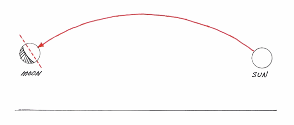
One prominent example of this is the Moon Tilt Illusion. If the Sun is illuminating the Moon under straight line geometry, such as in the Round Earth Theory, then it would be expected that the illuminated portion of the Moon will always point at the Sun, much like how when shining a flashlight at a ball the illuminated portion of the ball will always appear to point at the flashlight to observers positioned around the ball. It is natural and expected that the illuminated portion of a body will appear to point at its light source, like an arrow will point at its destination in space. However, in reality the light from the Sun will be seen take an apparently curved path across the sky, creating an illuminated portion of the Moon which points away from the Sun.

Credit: Professor Alan Myers, University of Pennsylvania (Source)
This topic is discussed at length on the page Moon Tilt Illusion
This effect can occur due to the curving of light. Those who believe that light is traveling straightly on large scales are put into a position where elaborate explanations are attempted, which upon close examination, ultimately fails to explain observations.
Celestial Sphere
Beyond the illuminated portion of the Moon, other celestial phenomena also experience this effect. The tails of comets, meteors, Aurora borialis, Milky Way, path of the Moon and Sun, and direction of the Moon's illuminated area, are all affected and curved upon the Celestial Sphere. See the page Celestial Sphere for discussion.
Indeed, it is the existence of these effects which allows for the possibility of alternate world models. Much of the reason for why the Earth was originally theorized to be a globe was based on celestial observations and the assumption of the straight line geometry of light. Phenomena such as the rising and setting of celestial bodies, spherical motion of the celestial bodies across the sky, and underlit clouds at sunset all suggested to early astronomers and philosophers that we lived on a round earth. If the straight line geometry assumption of light is put into question, so is the ancient theory of a spherical world.
Distances and Travel Times
Another point of discussion are distances and travel times. According to the classic Flat Earth Monopole Model with an Antarctic rim the East-West distances will diverge and spread apart as they recede beyond the equator towards the South. According to the Flat Earth Bi-Polar Model and the traditional Round Earth Model the distances beyond the equator will converge as they recede towards the South.
On this topic proponents of the Monopole Model generally point to various discrepancies.
Sea Travel
It is pointed out that sea travel in the South was slow and historically difficult, possibly because the southern distances were misconstrued. Victorian era Flat Earth organizations used reports of sea travel in the South from steam ships and sailing ships as evidence in favor of the Monopole Model.
Air Travel
Flights with Stops
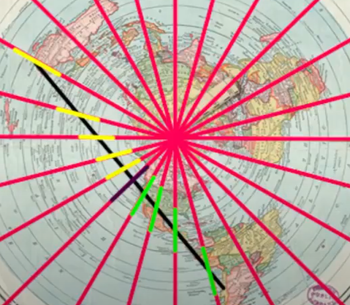
Long haul flights between different continents in the South often want to take passengers on a long circuitous route through through the Northern Hemisphere with one or more stops to reach an opposite Southern Hemisphere point, which could take more than 24 hours to reach the destination. When these flights with stops are plotted onto a Flat Earth map (Archive) they tend to curiously straighten out on the Monopole Map into a straight line to the destination. This is given as a suggestive piece of evidence.
Nonstop Flights
The focus in these discussions tends to steer towards the relatively few nonstop long haul flights between different continents which are said to exist in the Southern Hemisphere. Some question their existence, pointing out NASA's heavy involvement in air traffic, including involvement in the air traffic of countries like Australia.
Others suggest that the flights which do travel directly in the South may be taking advantage of jet streams and abnormal wind conditions that are known to exist in the South. Various anomalous data is pointed out which may suggest this to be the case. It could be logical that there are anomalous wind conditions in the South due to the fundamental nature of the system. A bucket filled with water stirred with a wooden spoon will tend to have faster velocities at the edges than the center. It is natural that since the edges of the habitable area are an anomaly, as is the weather. A flight which flies faster in the South could be argued to confirm this concept.
Southern Winds
A number of quotes can be found which suggest that the winds in the South are of an anomalous nature as compared to the North.
Australian Antarctic Division
http://www.antarctica.gov.au/magazine/2001-2005/issue-4-spring-2002/feature2/what-is-the-southern-ocean (Archive)
“ The Southern Ocean is notorious for having some of the strongest winds and largest waves on the planet. ”
BBC Earth
http://www.bbc.com/earth/story/20151009-where-is-the-windiest-place-on-earth (Archive)
“ There are huge belts of wind caused by the uneven way the Sun heats the Earth's surface. 30° north and south of the equator, the trade winds blow steadily. At 40° lie the prevailing westerlies, and the polar easterlies begin at around 60°.
Ask any round-the-world sailor and they will quickly tell you the stormiest seas, stirred by the strongest winds, are found in the Southern Ocean. These infamously rough latitudes are labelled the "roaring 40s", "furious 50s" and "screaming 60s". ”
Journal of Geophysical Research
https://agupubs.onlinelibrary.wiley.com/doi/full/10.1029/2003JD004179 (Archive)
“ The Southern Ocean is a vital element in the global climate. Its circumpolar current plays a crucial role in the global transport of mass, heat, momentum, and climate signals from one ocean basin to another. Moreover, the Southern Ocean hosts the strongest surface winds of any open ocean area, fostering strong heat, moisture, and momentum exchanges between the ocean and atmosphere. However, the Southern Ocean is tremendously undersurveyed by traditional observation methods because of the remoteness of the area and rough environment, causing the largest data gap of global oceans. ”
Faster Westerlies in the South
Cracking IAS Prelims Revision Files – Geography (Vol. 4/9)
“ The higher speed and greater persistence of the westerlies in the Southern Hemisphere are caused by the difference in the atmospheric pressure patterns as well as its variation from that of the Northern hemisphere. The landmass in the southern hemisphere is comparatively less and average annual pressure decreases much more rapidly on the pole ward side of the high pressure belt. ”
CIA World Factbook
https://www.cia.gov/library/publications/the-world-factbook/geos/print_oo.html
“ the ocean area from about latitude 40 south to the Antarctic Circle has the strongest average winds found anywhere on Earth ”
Issues in Flight Analysis
The page Issues in Flight Analysis showcases various points, such that long haul flights use jet streams, that jet streams enable faster than sound flight, that flights are highly dependent on weather, and that nonstop flights can stop for fuel.
Speed Anomalies
Jeran Campanella of Jeranism shows interesting anomalies with southern flights. Southern flights are curiously not tracked by satellite over most of their duration, causing the plane to hop around the map. From the sparse data available it is seen that True Airspeed can be seen to far exceed Ground Speed, suggesting that the flight is traveling faster than it thinks it is moving geographically, and much faster than the plane's rated cruising speed. The indicator switches between null and excessive speeds during its journey.
Magnetic Direction Anomalies
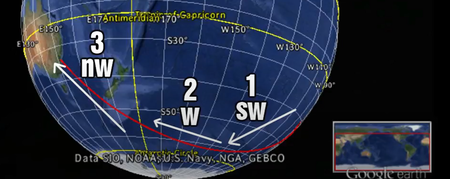
The directions as seen on a magnetic compass are anomalous when traveling from Chile to Australia. Max Igan reports that, according to his compass, when traveling between Chile and Australia that after takeoff the plane left Chile traveling towards the North-West and then towards the end of the flight it approached Australia from the South-West, despite his passenger terminal map displaying the RE directions. His experience is what should generally occur if the flight were traveling on a Flat Earth Monopole Model.
On a globe the flight should leave Chile from the South West and approach Australia from the North West:
On a Flat Earth Monopole Model the flight would leave Chile from the North West and approach Australia from the South West:
The above shows a straight line destination, but it is apparent that a curved path could also depart from the North West and arrive from the South West as well.
16 Emergency Landings
An interesting book 16 Emergency Landings Proving Flat Earth (pdf) by Eddie Alencar showcases examples where flights have made emergency stops which appear to align more with a Flat Earth model than with a Round Earth model. The book suggests that flights are not actually taking the RE routes, but are flying over the earth in line with a Flat Earth azimuthal projection.
Sydney to Houston North of Hawaii
Another analysis shows that flights traveling from Sydney, Australia to Houston, Texas fly North of Hawaii, when on a Round Earth the flights should travel South of Hawaii for the shortest route.


