
User:Tom Bishop
This section contains unorganized notes, links for further reference, and works in progress.
Works in Progress
Below are works in progress, and an area for miscellaneous notes. The content may change significantly or be rearranged.
Lighthouses of the World
Water Level Devices
Curvature Compression Test
Seismic
https://arxiv.org/pdf/1702.02789.pdf
https://arxiv.org/pdf/1702.02789.pdf
The Tides
https://www.youtube.com/watch?v=pC8rIVbyAqo
https://www.youtube.com/watch?v=n8gRr9TmWYo
Sinking Ship Effect
Bi-Polar Model
Mainstream Astronomy
- NOAA Solar Calculator
- Celestial Mechanics Cannot Predict The Solar System
- Problems of the Galaxies
- Problems of the Solar System
- Astronomical Prediction Based on Patterns
Topics Related to Relativity
Other
- Gravimetry -- fix misc
Flat Earth Star Trails
To review - https://www.youtube.com/watch?v=RkDqdoINhYI
Astronomical Nutation
Project Longstop - Consider deciphering meaning with references
Notes
Samuel Birley Rowbotham
Medical
The American Association for the Advancement of Science lists him as Dr. Samuel Rowbotham in his 1885 obit, as does the obit in Eng. Mechanic and World of Science. The Bookseller obituary confirms he was a practicing doctor of medicine as a "legitimate profession with great success.
Rowbotham's work is cited in medical journals.
https://i.imgur.com/X4xkYXn.png
Advertisement:
https://i.imgur.com/0TgprJE.png
Ballistic Missiles
Papers showing that missiles were designed to assume a Flat Earth:
Internal Guidance of Ballistic Missiles (1971)
http://www.dtic.mil/dtic/tr/fulltext/u2/722291.pdf
Videos:
NAVY Missile Instructor says that no earth curvature or rotation is assumed
Epicycles
History
Gravitational Redshift
https://arxiv.org/pdf/1512.09253.pdf
“ The second possible misconception relates to the notion that gravitational redshift experiments provide evidence for spacetime curvature. They do, but contrary to what is claimed in a couple of important modern textbooks on GR, a single gravitational redshift experiment does not require an explanation in terms of curvature. Rather, it is only multiple such experiments, performed at appropriately different locations in spacetime, that suggest curvature, via the notion that inertial frames are only defined locally. In the process of elaborating on this in section (3), we also take a swipe at the nomenclature associated with the “clock hypothesis”. ”
Sleddog Speeds
txt: http://publications.americanalpineclub.org/articles/12198311400/print
Latitude Origin
https://i.imgur.com/WOAF25a.png
Nullschool Map
Jet Streams
“ Jet streams are ever-present, relatively narrow, streams of high-speed winds undulating around the Northern and Southern Hemispheres ”
“ Within these streams, winds travel at different rates of speed, from some 50 miles per hour at the outer edges of the stream, to some 250 miles per hour at the center. Speeds as high as 300 miles an hour have been reported. ”
https://i.imgur.com/d0NUCyD.png
Jet Streams Enable Faster Than Sound Flight
https://www.wired.com/story/norwegian-air-transatlantic-speed-record/
“ OK, about that "subsonic" bit. You might know that the speed of sound at an altitude of 30,000 to 40,000 feet is roughly 670 mph. But Norwegian’s planes didn't break the sound barrier. Those near-800-mph figures represent ground speed—how fast the aircraft is moving over land. Their air speed, which factors out the 200-mph wind boost, was closer to the 787's standard Mach 0.85. (The older Boeing 747 can cruise at Mach 0.86, but is less efficient than its younger stablemate.) When talking supersonic, and breaking sound barriers, it's all about the speed of the air passing over the wings, which in this case was more like 570 mph. ”
Jeran Video - Jet Streams SH
https://www.youtube.com/watch?v=CaDw-6sslrc
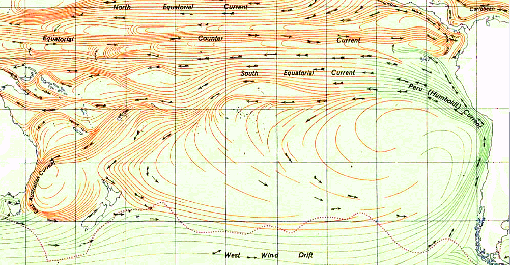
Trade Winds and South Pacific Gyre
https://en.wikipedia.org/wiki/Trade_winds
https://en.wikipedia.org/wiki/Trade_winds#/media/File:Map_prevailing_winds_on_earth.png
South Pacific Gyre
http://thejunkwave.com/what-is-a-gyre/
https://upload.wikimedia.org/wikipedia/commons/e/e4/South_Pacific_Gyre.png
Another illustration: https://books.google.com/books?id=bOg0EqqrDRgC&lpg=PA133&dq=%22jet%20streams%22%20%22southern%20hemisphere%22&pg=PA153#v=onepage&q=%22jet%20streams%22%20%22southern%20hemisphere%22&f=false
http://www.bbc.com/earth/story/20151009-where-is-the-windiest-place-on-earth
GPC and Lat-Lon distances
The coordinate system a GPS uses assumes that the coordinate points rest upon a sphere. The location of one coordinate point may be "accurate", but the distance between multiple coordinate points relies upon the Round Earth model, as Latitude and Longitude is a spherical coordinate system, and is therefore in dispute in these conversations.
Flights over the Southern Oceans
“ The Southern Ocean is notorious for having some of the strongest winds and largest waves on the planet. ”
http://www.bbc.com/earth/story/20151009-where-is-the-windiest-place-on-earth
“ There are huge belts of wind caused by the uneven way the Sun heats the Earth's surface. 30° north and south of the equator, the trade winds blow steadily. At 40° lie the prevailing westerlies, and the polar easterlies begin at around 60°.
Ask any round-the-world sailor and they will quickly tell you the stormiest seas, stirred by the strongest winds, are found in the Southern Ocean. These infamously rough latitudes are labelled the "roaring 40s", "furious 50s" and "screaming 60s". ”
https://agupubs.onlinelibrary.wiley.com/doi/full/10.1029/2003JD004179
“ The Southern Ocean is a vital element in the global climate. Its circumpolar current plays a crucial role in the global transport of mass, heat, momentum, and climate signals from one ocean basin to another. Moreover, the Southern Ocean hosts the strongest surface winds of any open ocean area, fostering strong heat, moisture, and momentum exchanges between the ocean and atmosphere. However, the Southern Ocean is tremendously undersurveyed by traditional observation methods because of the remoteness of the area and rough environment, causing the largest data gap of global oceans. ”
Listed Flight Times Skewed
http://www.travelandleisure.com/travel-tips/airlines-airports/why-flights-take-longer
“ Surprisingly, flight time is calculated from when the aircraft releases the parking brake (on push back) to when it sets the brake on arrival to the gate,” commercial pilot Chris Cooke told Travel + Leisure. “All that waiting in line during taxi and takeoff counts toward flight time.
Not surprisingly, saving money is another reason flights take longer today. “Airlines are able to save millions per year by flying slower," reveals a video from Business Insider. ”
A study which says they are skewing flight times:
“ Are you being told the truth about flight times?
Passenger jets have never been more advanced. With Boeing’s 787 Dreamliner, introduced in 2011, leading the charge, and new models like the 737 MAX and the Airbus A320neo following in its wake, the aircraft on which we travel are safer, smoother, quieter and more fuel efficient than ever.
They also appear perfectly capable of flying faster than their predecessors. Just last month the low-cost carrier Norwegian issued a celebratory press release after one of its 787 Dreamliners whizzed from John F. Kennedy International Airport in New York to London Gatwick in five hours and 13 minutes, setting a new transatlantic record for a subsonic plane. That’s three minutes quicker than the previous best time set by British Airways in January 2015.
So why, record-breaking feats notwithstanding, are airlines claiming it takes longer and longer to fly from A to B?
That’s according to research by OAG, the aviation analyst, carried out for Telegraph Travel. It found that over the last couple of decades, despite new technology, scheduled flight times - ie. how long an airline estimates it will take to complete a journey - have actually increased by as much as 50 per cent.
Looking at Europe’s busiest international route, for example - Heathrow to Dublin - it found that in 1996 the vast majority of airlines published a scheduled flight time of between 60 and 74 minutes. Fast forward 22 years and almost all claim the journey takes between 75 and 89 minutes, while a handful bank on 90 minutes or more. ”
WGS 1984
https://www.gpsworld.com/data-collection-of-wgs-84-information-or-is-it/
“ In the meantime, here are a few of the main differences between WGS 84 and NAD83:
-The coordinate system for WGS 84 is geographic, and the NAD83 system is projected.
-WGS 84 values are points in space, while NAD83 coordinates are physical locations on the Earth. ”
https://en.wikipedia.org/wiki/State_Plane_Coordinate_System
Background to NAD83
https://gisgeography.com/geodetic-datums-nad27-nad83-wgs84/
Datum definition:
https://www.nceas.ucsb.edu/~frazier/RSpatialGuides/OverviewCoordinateReferenceSystems.pdf
Truth Tokens -Universal Transverse Mercator (UTM) conformal projection
https://web.archive.org/web/20181115035011/http://truthtokens.com/map/?upm_export=print
https://forums.autodesk.com/t5/civil-3d-forum/coordinates-system/td-p/3179510
Hi All,
I think my question is for people who are living in WA, or someone know much about US coordinate systems:
What is World Geodetic System of 1984 and how's difference between it and NAD83 Washtington state planes?
Thank you,
Re: Coordinates System WGS-84 is a coordinate system designed for world-wide navigation. It takes into account the spherical nature of the planet. The coordinates are given in deg-min-sec format, common with polar coordinates, for latitude and longitude.
The Washington state plane system is a square coordinate system specific for the state of Washington. It supposes a flat plane across the face of the state. Northing and Easting are given in feet, based on straight line-of-sight distance.
Transformations Between NAD83 and WGS84